


Memory-Map

คำอธิบายของMemory-Map
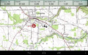
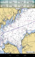
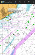
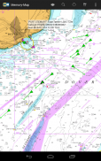
แอพ Memory-Map เปลี่ยนโทรศัพท์หรือแท็บเล็ตของคุณให้เป็น GPS กลางแจ้งหรือ Marine Chart Plotter ที่มีคุณสมบัติครบถ้วนและช่วยให้คุณนำทางด้วยแผนที่ USGS Topo แผนภูมิ NOAA Marine และอาจใช้แผนที่เฉพาะทางอื่น ๆ ได้
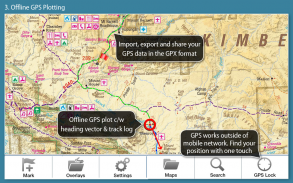
แผนที่จะดาวน์โหลดแบบทันทีและสามารถโหลดล่วงหน้าเพื่อให้สามารถใช้งานแบบออฟไลน์ได้ เมื่อโหลดแอพและแผนที่ไปยังโทรศัพท์หรือแท็บเล็ตแล้วเครือข่ายโทรศัพท์เคลื่อนที่หรือการเชื่อมต่ออินเทอร์เน็ตไม่จำเป็นต้องใช้สำหรับการนำทาง GPS แบบเรียลไทม์
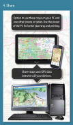
แอพ Memory-Map สามารถใช้เป็นเครื่องนำทาง GPS แบบสแตนด์อโลน แต่ยังสามารถใช้ร่วมกับแอพ Windows PC หรือ Mac (ดาวน์โหลดฟรี) สำหรับการวางแผนการพิมพ์และการโหลดแผนที่จุดและเส้นทางไปยังโทรศัพท์ / แท็บเล็ต .
หน่วยความจำแผนที่รวมถึงการเข้าถึงแผนที่ภูมิประเทศมาตราส่วน 1: 250,000 ฟรีและแผนที่ฟรีอื่น ๆ อีกมากมายทั่วโลก แผนที่รายละเอียดเพิ่มเติมพร้อมให้ดาวน์โหลดและซื้อด้วยตัวเลือกการทดลองใช้ฟรีก่อนเวลา จำกัด แผนที่ที่มีอยู่รวมถึงการสำรวจอาวุธยุทโธปกรณ์ Hema, USGS quads, NOAA, Admiralty ของอังกฤษและ DeLorme สามารถใช้แผนที่บนพีซีของคุณเช่นเดียวกับโทรศัพท์และแท็บเล็ต คุณลักษณะ Cloud Sync ช่วยให้คุณสามารถเก็บข้อมูลซ้อนทับบนอุปกรณ์ทั้งหมดของคุณ
คุณสมบัติรวมถึง:
เข้าถึงแผนที่และแผนภูมิทั่วโลกมากมาย
ดาวน์โหลดแผนที่ฟรีของตำแหน่งปัจจุบันของคุณโดยอัตโนมัติ
สร้างและแก้ไขเครื่องหมายและเส้นทาง
นำเข้าและส่งออกเครื่องหมายเส้นทางและแทร็กในรูปแบบ GPX ที่เปิดอยู่
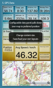
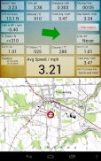
แสดง; ตำแหน่งหลักสูตรความเร็วหัวเรื่องระดับความสูงและค่าเฉลี่ย
พิกัดตำแหน่งรวมถึง Lat / Long, UTM และ GB Grid
หน่วยที่แสดงใน Statute, Nautical หรือ Metric
รองรับเซ็นเซอร์ GPS และเข็มทิศหากมี
ดัชนีชื่อไฟล์สามารถใช้แบบออฟไลน์ได้
ย้ายแผนที่ล็อคตำแหน่ง GPS และเลื่อนแผนที่โดยอัตโนมัติ
บันทึก breadcrumb trail / tracklogs
แบ่งปันเครื่องหมายตำแหน่งหรือ tracklogs เป็นไฟล์ GPX
ตั้งปลุก
เครื่องมือวัดทางทะเลแบบเต็มพร้อมสัญญาณเตือนภัย AIS, DSC และ Anchor
อินเตอร์เฟซข้อมูล NMEA ผ่าน WiFi หรือบลูทู ธ
สัญญาณเตือนการชนของ AIS พร้อมขีด จำกัด ที่ปรับได้สำหรับเป้าหมาย Class A และ Class B
แสดงการแจ้งเตือนและข้อมูล Nav บนนาฬิกา Android Wear
บารอมิเตอร์และญาติระดับความสูง
Memory-Map--เวอร์ชั่น2.9.0
(03-02-2021)
Memory-Map - ข้อมูล APK
เวอร์ชั่น APK: 2.9.0แพ็คเกจ: com.memorymap.mm2เวอร์ชั่นล่าสุดของMemory-Map
เวอร์ชั่นอื่น


แอปในประเภทเดียวกัน


